
A Tale of Two Cities: Albuquerque-Mendoza, #abq-mdz
- Andrew Bernard

- Apr 6, 2020
- 15 min read
Updated: Apr 15, 2020
Intro
Well, here we are in the middle of a global pandemic (COVID-19) and if you are reading this, you’re likely in some sort of isolation situation. I am currently in Mendoza, Argentina under full mandatory quarantine. No, I’m not talking social distancing. I’m talking police flying drones in the streets to arrest people for leaving their homes without authorization. Straight-up lock-down! I literally cannot leave the house for any reason and am now an American “stuck” in quarantine (cuarentena) in another country (Spoiler alert! - Future blog post in the works). This post is long overdue as I have been here for over a month, almost two! How the time flies. Nothing like quarantine to finally get to all of those overdue tasks, am I right?!
First and foremost, I hope that you and your loved ones are safe and that your life has not been impacted tremendously from this alarming situation. If it has been, I hope it is in a positive way. Secondly, thanks for tuning in to read. If you’ve read my previous post, Looking to the Past for Solutions for the Future, we left off in search of answers to some critical questions by the development community in Albuquerque, New Mexico in response to adopting more sustainable development practices such as green infrastructure (GI) and low-impact-development (LID). Today’s post is intended to provide some context about a current research project I am conducting in response to these questions and to illuminate some of the aspects that I find most important in this pursuit. I hope you enjoy it!
Yet, I couldn’t get those questions out of my mind about the acequias in Mendoza. “What if I could answer those questions?”, I thought. “Would I learn something new? Would it make a difference?” “What more could we learn from each other?”


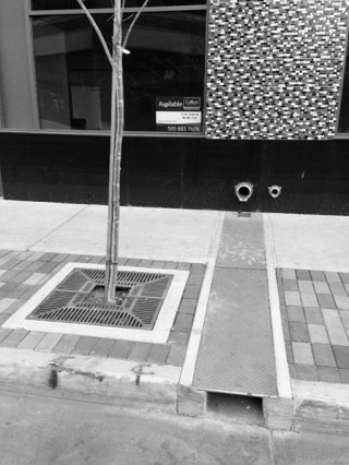


Images of downtown Albuquerque, New Mexico intended to illustrate evidence of the existing planning paradigm and its regard to natural systems in the urban environment. Water is carried away quickly to the stormdrain carrying with it many contaminants (top left). Opportunities to use runoff water for irrigating trees or integrate functions are often overlooked (top right). Trees are given insufficient soil and surface space to grow (bottom images). Image credits: Author
Going the Distance
By nature, I am someone who enjoys solving problems, especially when it comes to changing habits and challenging the status quo. It seems there is always a new, better, or different way to do something and in our rapidly-evolving world, there is no shortage of necessity for this mindset. When I hear “It can’t be done” or “We’ve just always done it this way”, my ears perk and I immediately start strategizing, because in my mind, these are indicators of a problem. Throughout my life, this trait, exacerbated by my ambition, has often landed me in hot water with a reluctant employer or has led me to invest large sums of time and energy into seemingly fruitless pursuits. But then, every once in a while, I engage with a challenge where all of these experiences coalesce into one really big success!
Dedicated to finding answers to these questions and contributing to an important global dialogue regarding sustainable development in arid regions, I’ve returned to the “Desert Oasis”, the city of Mendoza, Argentina, only this time as a Fulbright Scholar. A pursuit almost 7 years in the making, this 9-month grant has afforded me the opportunity and time necessary to dive deep into identifying and understanding the practices of planning, landscape architecture, design, water management, and sustainability that contribute to the proliferation of this unusual city. Here, I’ll be conducting a case-study of the specific traditions and historic practices, benefits, and challenges involved with maintaining what I refer to as the heritage infrastructure system (acequia-tree-city infrastructure) that has given the city this identity and ethos of integrating natural systems with the built environment.

Mendoza, Argentina is one of the few arid cities in the world where historic traditions of city planning and urban design practices are maintained that leverage the bioclimatic benefits of natural systems to respond to the harsh environment. Prior to the advent of modern air conditioning, cities in arid regions had a more symbiotic relationship with nature, integrating these natural processes into the design of cities and architecture. Most modern cities have long since abandoned these practices for those seemingly less sustainable and symbiotic. I believe that there is much to be learned by examining the past. By studying a city that has not abandoned these traditions of designing with nature, we can inform more sustainable or integrated planning practices in similar arid-region cities around the world, especially Albuquerque, New Mexico (USA).
If you recall, Mendoza shares many parallels with New Mexico and the southwestern U.S. and, therefore, serves as an excellent comparative laboratory of sorts (more about this below). My hope is that if successful examples of sustainable planning in a comparable arid context can be clearly demonstrated to those who need to understand them, then perhaps it will inspire or at least encourage these parallel cities to consider adapting or shifting conventional methods and ways of thinking. Additionally, this is an opportunity to engage in dialogue about issues concerning arid regions around the world, shared values, exchanges between cultures, and promoting opportunities for collaboration between our two countries. If a comparative analysis is feasible for exploring aspects of urban design and sustainable planning, perhaps there are many other aspects to be explored by others (anthropology, geography, engineering, water management, law, etc). It is my intention to utilize this blog as a method for sharing many of my findings and thoughts as I carry out this project and pursue my goals in order to disseminate and share this information.
You can follow along as well on the project Instagram account @placeintegrated or at #ABQ-MDZ

During my time here, I have the following goals:
Understand cultural values of the acequia-tree-city heritage infrastructure or “Desert Oasis”. Why do people value their green spaces and trees so much here? Why do they continue to allocate substantial resources to support these practices in light of many constraints?
Develop a case-study of the urban design and city planning practices in Mendoza (a review of specific practices and principles of green infrastructure being used in Mendoza and how they are applied, maintained, and managed).
Explore the culture of Mendoza and Argentina through the lens of water, urban ecology, public space, and climate change.
Identify opportunities for future research collaborations by illuminating the parallels between the two cities (Albuquerque and Mendoza) and surrounding regions.
Mendoza, Argentina - The “Desert Oasis”

If you’ve ever tasted Malbec wine, you’ve experienced a part of Mendoza, Argentina. As it has become world - famous for its wines and vineyards, to some, Mendoza is significant for another reason. Touted as the “Desert Oasis”, Mendoza is a unique desert city that sustains a vibrant and robust urban tree canopy and plentiful green spaces in the middle of the desert, hence its nickname. This canopy along with many of the green spaces throughout the city are supported by a network of irrigation waterways or acequias, or ditches, that run along the margins of the streets (see previous post for more information on acequias).

The cohesiveness and cumulative area of this integrated infrastructure offers many environmental and social benefits such as reducing energy demand for cooling and improving urban comfort (shade reduces urban temperatures), improving air and water quality (trees sequester carbon and can remove contaminants from water through their roots), enhancing human health and well-being (connections to nature and water are critical to human physical and mental health), and increasing ecological biodiversity (provides habitat for many species). In addition to these many environmental advantages, the oasis provides a distinct aesthetic and identity for the city, which further enhance the urban experience and provides economic advantages (property values, tourism, etc.). The tree-lined streets of the Desert Oasis are arranged to channel the winds from the west into and through the city to improve air quality and regulate temperature. The trees act as “scrubbers”, removing carbon and other pollution from the air as it passes through the green corridors. There is a great webinar on this concept titled “The Lungs of the City: Landscape Design for Air Quality" if you would like to learn more.


To provide you with a bit more context, Mendoza was founded by indigenous peoples (Huarpe) whom constructed an intricate network of earthen irrigation channels to support small-scale agriculture in this arid landscape. When the Spanish colonists invaded and “re-settled” the area, instead of eliminating the existing infrastructure, which was common, they were so impressed with the system that they built the new city around it and subsequently formalized the irrigation channels into an organized network known as acequias (adapted from North-African/Moorish practices). As with most Spanish settlements in the Americas (including Albuquerque, New Mexico), the city was then constructed in accordance with what is known as the Laws of the Indies. Enacted in 1573, this was basically the urban design template for all new Spanish colonies in the “New World”, which dictated a formal arrangement of parcels, buildings, public spaces, and infrastructure including roads and acequias with flexibility for geographical nuances. Because of this, most Spanish colonial cities throughout the world have a very similar layout and aesthetic (click here to learn more about Spanish-Colonial town planning).


On March 20, 1861, Mendoza experienced a devastating earthquake which completely leveled the city, creating almost a blank slate. This presented the City of Mendoza the opportunity to completely re-think the city layout. If you work in developing the built environment realm, you know this is a very rare opportunity as we are constantly working around many existing complex systems and physical features that cannot always be changed. For this, the City of Mendoza gave considerable thought to the future needs of the city.
At the request of the then Minister, the city enlisted French surveyor Julio Balloffet to help realize a new vision and subsequent masterplan for the city. Ballofet’s approach was somewhat austere and homogenous as he designed the city as a grid focused on the concepts of order, hygiene, efficiency and regularity where the layout of streets, sidewalks, and public gathering spaces are arranged for ordering traffic and efficient evacuation in the event of an earthquake. Fortunately, he enlisted the talent of the French-native landscape architect, Carlos Thayes, who enhanced the city plan through a number of parks and green spaces with the clear objective of incorporating environmental quality into the urban fabric (Villalobos, 2015). It is understood that Thays’s influence in this process set a tone for the future on Mendoza’s environmental awareness in design. Though Thays is most notable for his design of the massive Parque San Martín at the west edge of the city, likely the most compelling aspect of his vision for the city is that it very overtly integrated the existing acequia system into the urban fabric instead of dismissing it. While this new plan was primarily a response to organizing the city to provide adequate refuge space for public safety during earthquakes, the prevalence of numerous public parks, green spaces, plazas, and a significant urban forest supported by the urban acequias are a testament to the demand for these amenities. Through time these spaces have become an essential part of society, and in turn, they have influenced the culture and identity of Mendoza that we see today.

What is most interesting to me about this is that Mendoza had the opportunity to change many things about the layout of the city (when offered a blank slate after the earthquake), like not incorporating the existing acequias or not adding substantial green spaces (which was almost the case if it were not for the influence of the Landscape Architect, Carlos Thays); however, this new plan not only incorporated these elements, but revered them as critical to the proliferation of the city. Clearly Thays had the foresight to leverage the environmental benefits of using green spaces and tree canopy to provide benefits for the city, but this would not have been possible if not for the demand by the public.
Even today, in the face of increasing water scarcity and demand pressure on this resource, the city continues to allocate large quantities of water to support this robust urban forest in the middle of the desert. They also take their trees VERY seriously. In fact, they have an entire department dedicated to maintain the oasis and there are hefty fines for damaging or intentionally altering trees. You can’t even prune a tree without special consent here. To some, it may seem extreme, but this practice seems to reflect a cultural ethic of environmental stewardship, or at least one that values utilizing ecosystem services or natural systems to enhance the urban environment and well-being for all inhabitants.
Green Spaces and pubic spaces have had a profound influence on the development of the culture and social behaviors in Mendoza (Bochaca, 2005).
Note: We will discuss these topics more in-depth in a future post, but for now, please make sure to check out this great synopsis of Mendoza’s green-infrastructure,“Green Mendoza and its acequias: A Mexican architect’s impressions of urban greenspace in an Andean Argentine city”, written by landscape architect and researcher, Adriana Zuniga-Teran, PhD, at the University of Arizona. Also, there are several books written by architect and author Jorge Ricardo Ponte who is an authority on all things acequias and the history of development in Mendoza. Here is a video that captures much of his work and provides a great (brief) history of Mendoza in relationship to its acequias. Definitely worth the 20 minutes if you are at all interested in water, urban design, or water infrastructure.
Mendoza has some great resources to learn about its urban history. Click here if you'd like to learn more!
Parallels
When conducting a comparative case study, it is imperative to ensure whatever you are studying is relative to the questions or problems you are trying to answer. That is to say that you need to try to compare apples to apples, not apples to oranges. In the case of this project, we are trying to find evidence of successful sustainable practices in an arid city comparable to Albuquerque. While there are many arid cities in the world that have some similarities to each other (most arid cities around the world share some connection to acequias or an equivalent irrigation system), there are abundant similarities and parallels that exist between Albuquerque, New Mexico (USA) and Mendoza, Argentina making these cities excellent comparative laboratories.
As you can see in the composite image below, even at first, Albuquerque and Mendoza bear a striking resemblance to each other. Both located at the foot of mountain ranges in arid regions, this characteristic is the basis for many other parallels outlined below.

The following are examples of other interesting parallels that support the value of these two cities as comparative laboratories for studying a range of topics:
Geographic Parallels

Albuquerque is located at approximately 35° N latitude. Mendoza is located at approximately 32° S latitude. This almost equidistant proximity to the equator places both cities in zones designated as semi-arid to arid. Because Mendoza is in the southern hemisphere, it experiences the opposite seasons to those in the United States (i.e. summer in the U.S. is winter in Argentina).
Both cities are located in the foothills of large mountain ranges and are headwater-dependent meaning all of their surface water resources come from melted snow in the mountains or other localized sources.
This location also has great effect on the local climate as the mountains create unusual climatic conditions causing a phenomenon known as the rainshadow effect.
Both cities are located in zones designated as arid.
Physical Parallels
Both cities are at high altitudes, which contributes to their arid climate and intense solar radiation. This aspect is important when considering the types of vegetation that exist or can survive in these regions.
Long histories of utilizing earthen materials for building construction (Adobe)
Many similar species of vegetation
Similar landscape typologies (High-Desert, scrublands, mesquite, mountain zones, riparian corridors)
Shared history of extensive water management infrastructure (acequias and other irrigation/drainage infrastructure)
Climatic and Environmental Parallels


Graphics intended to demonstrate the similarities in climate, population, and elevation of Albuquerque (left) and Mendoza (right). Image credit: Author
These parallels are likely the most important factors as climate has an effect on so many aspects of a city. Both cities are classified as arid climates meaning that they receive less than 10 inches (254 mm) of rainfall in an entire year. Most of this is received in a short window of time during the summer months. Classified as Mid-Latitude Desert and Steppe (Köppen Classification – BWk), the climates of these regions have the following parallel characteristics:
low relative humidity and cloud cover
low frequency and amount of precipitation
moderate to high annual temperature
moderate to high monthly temperatures.
Additionally, the climates of these two cities share the following attributes and problems related to climate and environment:

They are Rainshadow communities
They both experience strong seasonal wind patterns. In Medoza, Viento Zonda (sudden strong winds caused by temperature shifts in the Andes Mountains of Argentina) and strong Spring winds common in the southwestern United States
Hydrology regimes bring most annual rainfall in a short window through strong summer storms known as Monsoons
Intense heat from solar radiation. High potential for photovoltaic energy production
Low humidity, high evapotranspiration rates
Experiencing increased urban temperatures or “Heat Island Effect”
Degradation in water quality due to rapid urbanization
Experiencing Increasingly intense droughts or "sequias"
Both cities are experiencing desertification and loss of arable lands due to disturbances to vegetation patterns and exacerbated by drought

“These climates are dry because of extreme continentality and the effect of high elevations (Pidwirny, 2006)”. Being located at the center of a continent limits the amount of moisture supplied from ocean sources and without this moisture, precipitation cannot occur. The presence of mountains upwind of these climates can further reduce moisture availability because of the rainshadow effect. Winter temperatures also tend to be quite cool (Pidwirny, 2006). A peculiar aspect of the Sandia mountain range on the east side of Albuquerque is that it does not follow the typical rules of a rain shadow. Even though the prevailing winds come from the west, the east side accumulates more moisture due to the intense sunlight absorbed by the mountains on the west face.
Historic and Cultural Parallels
As discussed in the previous post, Mendoza and Albuquerque have very similar beginnings. One of the most direct connections between these two cities is the shared history of acequias and the origins of city development. They were both “formally” founded on indigenous peoples’ land as Spanish-Colonial settlements in arid regions based on the mandates of the Laws of the Indies, which means they both established a rich network of acequias as an essential infrastructure in the city.
Spanish and indigenous peoples influence
Acequias
Strong influence of water management in each culture
Wine and viticulture
Outdoor adventure and tourism (rafting, hiking, biking, etc.)
Both experiencing serious water scarcity problems and challenged with sustainable management in face of climate shift.
Shared history of environmental and resource exploitation
Similarities in arts, food, and music
Shared social and environmental problems due to rapid urbanization away from the city core (also known as sprawl). Social divides created by affluent gated or private enclaves outside of the city

Why is this study Important?
One of the greatest challenges we face is today how to support more sustainable and regionally-adaptive development practices for new and existing urban centers in anticipation of changing climate conditions. This is particularly true in arid regions. In the next ten years, urban centers located in arid regions around the world will experience the most rapid growth in population and urbanization. Coupled with rising global temperatures, degradation of environmental systems, and dwindling access to green spaces, these urban centers could soon become entirely inhospitable places to live for all inhabitants.
Given the vulnerability of arid climates to climate shift, we must reconsider arid cities as ecosystems rather than as engineered concrete structures. Shifting away from outdated and unsustainable practices of city planning and urban design towards symbiotic relationships between people and nature can be facilitated by learning from successful practices in other arid cities around the world, such as Mendoza. As arid regions, such as New Mexico (and surrounding regions including northern Mexico, Arizona, Texas, Colorado, Nevada, and southern California) require special consideration for these practices (i.e. the same practices from more temperate climates are not applicable), I decided to follow through need to glean relevant precedents or successful examples of sustainable practices being applied in other arid cities.
Change Is Hard
“If you always do what you’ve always done, you’ll always get what you’ve always got.” Anonymous quote from TopRight Partners
Let’s face it, change is hard. We have all experienced change in many ways in our lives in various ways, shapes, and forms. It’s never is easy, yet somehow, we always seem to adapt. As humans, as individuals, we are resilient and find ways to arrange our lives and attitudes around life’s obstacles and ups and downs. As a whole, as a culture or society, today…well, I believe we have yet to truly embrace this ability when it comes to changing traditions of investments in planning and designing our cities (take for instance our current situation with COVID 19 and its effects on our lives and our society... food for thought). With access to more information than ever before, we have every advantage to make informed decisions that can lead us toward new and more sustainable practices of development, yet it often times feels like there is a resistance to change out of some innate fear of doing things differently. So, now that we are facing such unpredictable climate changes and our outdated traditions of development have become part of the problem, will we be ready to face fear? Are we ready to change? Can we adapt in time or will our collective apprehension to change be our greatest loss?
What we do know is that these are big, multidimensional issues that require many different perspectives and input from an array of disciplines like planners, architects, scientist, and engineers. It also takes a global dialogue. This multifaceted and multidisciplinary approach, when coupled with effective leadership and communication, can give us a fighting chance. As discussed in the previous post, landscape architects and urban planners offer many of the essential change-management skills and vision needed to be these effective leaders in their communities (also managing your ego is paramount to being an effective leader, but that is a topic for another day). As a landscape architect myself, I find that my most valuable skills center around communication - the ability to listen and empathize, which allows you to fully understand a situation and the needs for developing a solution or strategy. The ability to illustrate or express ideas visually allows you to connect with a broad audience. These skills have helped me identify a need in my community for evidence, information, and for inspiration of successful and relevant green infrastructure practices in arid regions in order to help decision makers feel more comfortable about trying new methods - a need to become a catalyst for the change I wish to see.
If you would like to learn more about this project or would like to discuss how to get involved, please feel free to contact me any time! Thanks for taking the time to read this post.
Works Cited
Bochaca, F. (2005). Green in the Urban Structure of Mendoza. ARQ , 60, 68-71. Retrieved from https://scielo.conicyt.cl/scielo.php?script=sci_arttext&pid=S0717-69962005006000013
Gonzales, M. (2014). The Evolution of the Urban Acequia Landscape of the American Southwest. Irrigation, Society and Landscape. Tribute to Thomas F. Glick, (pp. 1-16). Albuquerque. doi:10.4995/ISL2014.2014.200.
Pidwirny, M. (2006). "Climate Classification and Climatic Regions of the World". Fundamentals of Physical Geography, 2nd Edition. Retrieved April 1, 2020, from PhysicalGeorgraphy.net: http://www.physicalgeography.net/fundamentals/7v.html
Ponte, J. R. (2008). Mendoza, Aquella Ciudad de Barrio Illustrado: Historia de una Ciudad Andina, Desde el Siglo XVI Hasta Nuestros Días, 1st ed. Buenos Aires: CONICET.
Villalobos, A. (2015, November 9). Urban History of Mendoza from the 16th to the 21st Century. Retrieved March 26, 2020, from Universidad.com: http://www.unidiversidad.com.ar/historia-urbana-de-mendoza-siglo-xvi-xxi?utm_campaign=Suplemento&utm_term=55


Great work Andrew! Seems like there is endless research at this spot. Did you know about the similarities before you chose this place?
This is a very promising research project that deserves to be read and supported. Congratulations Andrew!
Gracias por esta publicación, Andrew. Lo disfruté mucho. Además, la fecha del mapa de Sanborn es 1891, no 1831. :-)